Showing posts with label WAWeekend. Show all posts

Saturday, August 3, 2013

WAWeekend: On the Corner of Bitter and Sweet


Product DetailsIf you are a reader, you probably recognize the title of this post as part of the title of  Jamie Ford’s New York Times best-selling historical novel, Hotel On the Corner of Bitter and Sweet.

His story of love and friendship during a dark time in our country’s history is set in Seattle. It was during World War II, when President Roosevelt issued an Executive Order sending Japanese-American citizens (many born here) to internment camps for the duration of the war.


seattlept2 005
Like elsewhere in the country, it uprooted families in the Seattle/Puget Sound area. Many families  stashed their bags in the basement of the Panama Hotel, before leaving for the camps.  (Some of those belongings were never reclaimed. They can be seen through a section of glass flooring in the present-day Tea House.)

seattlept2 009

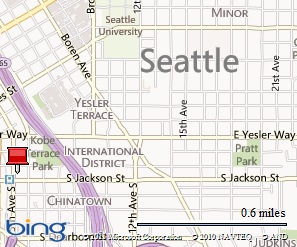
A few weeks ago while researching another article I am writing, I made my first I visit to The Panama Hotel, located in Seattle’s Chinatown/International District – the same hotel as featured in Ford’s book. 

So taken with its ambiance and history, was I, that I’ve since returned to its Tea and Coffee house with another  friend.

seattlept2 008
Panama Hotel Lobby

Both visits have prompted me to not only read the novel but to also learn a bit more about what was once  Seattle’s Nihonmachi, or Japantown, that grew up in this southeastern corner of Seattle.

Main Street, on which the hotel is located, was once the main spine and economic hub of Nihonmachi, an area which reportedly stretched for many blocks.

PicMonkey Collage
History is everywhere in the hotel and tea room pictured here
The walls of the hotel and its Tea/Coffee House are lined with photos of this once-bustling part of town along with hand-drawn maps reconstructing the former area. Names are added by those who still remember.

The vibrancy of that long ago Japantown was described by HistoricSeattle.org:

“This neighborhood became a diverse tapestry of homes, churches, grocery stores, theaters, language schools, hotels, restaurants, bathhouses, and other businesses interweaving with the edges of other Seattle communities nearby.

Seattle's Japanese American population reached its peak in the early 1930s with a population of roughly 8500, but it didn't last.”

Seattle 061
Hing Hay Park - Chinatown/International District Seattle

While the pulse of the entire International District seems to be getting stronger in recent years, the renovation of the Panama Hotel -- designated a National Historic Landmark in 2006 -- is contributing to the life of the area. 

My friends and I were among a  steady stream of customers – hotel guests and those, like us, who had come for the refreshments – at the hotel. 

PicMonkey Collage
Teas galore are available as well as Italian roasted coffee drinks

We had hoped to see the hotel’s basement where there remains one of the few intact Japanese bathhouses, (Sento) on the West Coast.  We didn’t, though, as we’d missed the regularly scheduled tour, led by the hotel owner  . . .Next time!

If  I’ve encouraged you to visit, keep in mind they have a regular Happy Hour in the Tea/Coffee room. This August and September (2013) at 2 p.m. on Saturdays there’s Panama Hotel Jazz, featuring music inspired by the novel and Oscar Holden, ‘the patriarch of Seattle Jazz’.  Admission is free.


If You Go:


Map picture


Panama Hotel, 605 1/2 Main St.  is European style with shared bathrooms; published rates are $90 single, $125 double. (TripAdvisor reviews swing wildly on this hotel, and make for entertaining reading). Phone: (206) 223-9242      Fax: (206) 624-4957  E-mail: reservations@panamahotelseattle.com, web: www.panamahotelseattle.com

Panama Tea and Coffee House, adjacent to the hotel lobby, at 607 Main St., Phone: (206) 515-4000
Call for tour dates, times, and prices.

The links above take you to the Amazon.com site to read more about the book.

Saturday, July 27, 2013

WAWeekend: On the Spirits and Ale Trail

A couple years ago I visited the Yakima Valley researching a Washington Ale Trail travel article for the Seattle Times and followed a customized ‘ale trail map’ I’d developed for myself. 

ChelanToppPort2010 104
That’s because the tourism folks in this cradle of Central Washington’s wide open spaces and agricultural lands didn’t have such a document. . .but, they promised, it was coming.

ChelanToppPort2010 107

They did have ‘wine road’ maps because those producers of the grapes and the makers of the vino are pretty much the headliners of the area – and have been for the past few decades. That wasn’t of much use because I was on the trail of ale. . .

MooCardAleTrail 072

The hop – the basic ingredient of ales – has been grown in the Yakima Valley for decades. High school chums used to earn spending money by ‘stringing hops’; twirling those twisty little shoots around the strings that would lead the vine skyward as the summer continued. Hop kilns, those enormous bigger-than-barns wooden structures used to dry the hops at harvest time dotted the landscape.

ChelanToppPort2010 105
Hop Vineyards in the Yakima Valley
Here’s  the kicker: 78% of the hops grown in the United States are grown in the Yakima Valley!

MooCardAleTrail 087
American Hop Museum - Toppenish, WA

International visitors make treks to the American Hop Museum in the small Lower Yakima Valley town of Toppenish but not a lot of folks on this side of the state or elsewhere, I suspect, even know of its existence. (It is well worth a visit if you’ve never been there!)

MooCardAleTrail 084
Hop cluster

Back to those tourism folks and that map they promised. . .just this week I got a news release with a link to:

 The Yakima Valley Spirits and Hops Trail website which has that promised map, a list of upcoming events, ‘sip spots’ and ‘guzzle and grub’.

Kudos to those folks because it’s an amazing piece of work and will serve any visitor well! Click the link above and check it out.

Here’s a couple of the events you’ll find listed there:

Annual Apple Valley Kiwanis Wine Country Trek Sat.– Sun., September 28 - 29

A scenic two-day, 120-mile bike ride, round-trip from Yakima to Prosser, through vineyards, hop fields and orchards. Start time from Yakima on Saturday is 8:00 a.m. returning Sunday at 6 p.m. Registration is $135 per cyclist with all proceeds going to Kiwanis community and youth service projects. This event coincides with the Hot Air Balloon Festival and the Harvest Festival in Prosser. Registration includes our famous gourmet dinner, the balloon glow, overnight camping (indoor and outdoor) in Prosser, Sunday morning breakfast, baggage transportation and break stops. For information, visit www.kiwaniswinecountrytrek.com

MooCardAleTrail 073
Finished product: ales


Attendees at the 11th Annual Fresh Hop Ale Festival can enjoy selections from numerous participating breweries in addition to brewing demonstrations, a cigar tent, food from local restaurants, live music and street dancing. The Festival begins at 5 p.m. and will continue until 10 p.m. Ticket prices are $30 if purchased in advance and $35 at the gate. All proceeds benefit Allied Arts of Yakima Valley which coordinates art programs, classes and events for the community. Pre-sale ($30) tickets are on sale at local businesses around the Yakima Valley during regular business hours through noon on Friday October 4. Plenty of tickets will also be available for $35 at the gate. Ticket price includes a commemorative beer glass and $6 scrip (used instead of cash for beer and wine, but note that food is cash only and that the event is 21+ only. ID is required for entry. For more information, visit www.freshhopalefestival.com

If  You Go:

Map picture

There are daily flights from SeaTac (Seattle Tacoma International) to  Yakima. Driving time from Seattle is about three hours to the Lower Valley;  little more than two hours to Yakima.

That’s it for this weekend’s focus on Washington State.  As always thanks for the time you spend with us. Hope you’ll tell friends to come along on our journeys together.  They can sign up to receive the posts  by going to the home page, www.travelnwrite.com.

And a request to our Facebook followers:  if you have a post that you particularly like, please ‘share’ it on your page – that what keeps the page in circulation!
Happy and Safe Travels~

Saturday, July 20, 2013

WAWeekend: Seattle’s Summertime Blues

Flying in and out of Seatac International Airport this week provided us a cloudless (finally!) sky-high show of Seattle.  And because I so often sing the blues about the area’s clouds and rain,  it seemed only fair to show you some of the other Seattle blues – its sky and water - as well. 

Vegas60Seattle 123

Seattle grew up on Elliott Bay pictured above.  In fact, much of its southern area – now home to major league sports stadiums (that portion in the mid right hand side of the photo) was once tidal flats that stretched even further south to the mouth of the Duwamish River.  The area was populated by the Duwamish people until the early settlers arrived in the 1850’s. (The lake to the top left is Lake Union and body of water stretching across the top of the photo is Lake Washington.)

Vegas60Seattle 021

Those of us living on ‘the east side’ of Washington State’s King County must cross Lake Washington to get to Seattle (or take long looping routes around the north or south ends of the lake).  The photo above shows Interstate 90 as it passes a tip of Bellevue to the lower left, crosses Mercer Island  and continues across the lake into Seattle.

Vegas60Seattle 127

Seattle has become a gateway for Alaska-bound cruises ships that ply the waters from spring until fall with weekly trips north.  So prolific is the cruise industry’s presence  -- Carnival, Celebrity, Holland America, Princess, Royal Caribbean and Crystal among them -- that a new cruise terminal, Pier 91, in the area known as Magnolia, was opened a few years ago.  (It, and a nearby grain elevator are pictured above.)

Vegas60Seattle 004While some of the ships dock at Pier 91 others continue to sail from  the more centrally located Bell Street (Pier 66) terminal, pictured below.
Vegas60Seattle 015Cruise enthusiasts who want to read more about the cruise industry in Seattle  should check out this Port Authority’s link – which even provides a list of ships and their sailing dates: http://www.portseattle.org/cruise/Pages/default.aspx


One of Seattle’s favorite waterways – and a popular tourist attraction -- is the Hiram M. Chittenden Government Locks, aka ‘the Ballard locks’ (pictured below) the latter being the name of the area in which they are located. 
Vegas60Seattle 130

The Ballard Locks are the link between Seattle’s fresh water Lake Union (and Lake Washington via what is called the Montlake Cut) and the salt-waters of Puget Sound. Ships traveling through the locks are raised or lowered to match the water level they are entering.

Vegas60Seattle 131

So popular are these locks there is even a Facebook page that updates regularly with news and activities about the place:  https://www.facebook.com/ChittendenLocks

That wraps up this WAWeekend – we are heading out to enjoy some of those blue skies!  Thanks for stopping by today. Hope you get a chance to explore some close-to-home destination where ever you are in the world and we’ll see you back here on Travel Tuesday!

Saturday, July 13, 2013

WAWeekend: Seattle’s Summer Sizzlers

“Oh yes, we ‘know’ Seattle.  We went to its market. . .Pike Place Market!”

Time and again we meet people on our travels who place our world by recalling a visit they’ve made to Seattle’s iconic public market. There was a time we used to regularly beat a path to the market when we found ourselves in the Emerald City.

Seattle 014

We live so close to Seattle now that like other of its destinations, we go there when the occasional out-of-town visitor comes along.

That is until this week when one of Seattle’s glorious sunny days and a freelance article I am working on, lured me back to this century-old market with post-card perfect views overlooking Elliott Bay.

I decided to stop at a few of my old favorites and seek out at least a couple new spots to tell you about this weekend.

Seattle 019Let’s start under the Market Clock (erected during the Great Depression) at ‘Rachel’, the piggy-bank  (donations go to the Market Foundation)brings out the photographer in all visitors:


Seattle 027

Rachel is right in front of the boys who throw the fish when making sales, so you have to watch that show again, even though you know what’s coming and now matter how often you've seen it before:

Seattle 025

Note:  this area is congested with crowds waiting to see the antics of the sales staff – I had to muscle my way through the throngs to get to the stairway nearby (and kept my purse clutched tightly to my chest. . .just in case there were some among them more interested in my belongings than the fish show).

The Gum Wall:  Egad, how I had never visited this place, on Lower Post Alley (almost under the fish company) before? Now that I have, I probably don’t need to return. This, is as its name implies is a wall of gum, chewed gum to be exact, that seemed to draw as many photographers as those shooting out over the bay.  Not to  miss ‘a photo opp’:

PicMonkey Collage

The Urban Garden:  This was also an area new to me but it’s also new to the Market.  And a pleasant contrast to the Gum Wall almost below it.  This raised bed garden – the first seeds planted in April this year --  will provide fresh produce to low-income residents who live in and around the Market and who visit the Pike Market Food Bank and Senior Center:

Seattle 023

From the garden I had one of the best views ever of Seattle’s Giant Wheel that opened in Summer 2012 at Pier 57:

Seattle 024

If you are like me, the real draw of Pike Place Market continues to be the longtime food and flower vendors (Sadly, it seemed a number of the produce and flower stands that once lined the main corridor have been replaced by souvenir and gift stands – hopefully it is because the harvest season isn’t yet in full swing):

PicMonkey Collage

That’s it for this weekend’s WAWeekend, when we visit close to home in Washington State.  If you are heading to Seattle, put this Market on your must-see list. It is open year-round.

If You Go:

For the latest information on Market operating hours, how to sign up for guided tours, and the latest happenings, visit the Market website:  http://pikeplacemarket.org/

Note:  In the summer ,the market by mid-day is usually crowded. It is a popular stop for cruise ship passengers – three ships were in port on the Friday I visited, not to mention the land-based tourists. Plan your visit accordingly.

Saturday, July 6, 2013

WAWeekend: From ‘Blogosphere’ to Mt. Baker

Would you believe it took a Canadian, who lives in South Korea to get me to Mt. Baker, in northern Washington State for the first time in my life?

Washington, the place I’ve lived my entire life, I might add.


And, I have the blogosphere to thank for planting the seed some two years ago that made this trip happen.

Regular readers know that each week TravelnWrite is a part of Travel Photo Thursday hosted by Budget Travelers Sandbox, a blog created by Nancie McKinnon, an educator from Halifax who teaches at a South Korean university. 

Over the year’s Nancie and I have gotten to know each other in the usual blogosphere way; reading posts, making comments,responding to comments and writing occasional emails.

Out of the blogosphere. . .

Nancie, two weeks ago, was en route  to Halifax and made  a stop in Vancouver, B.C. to visit a friend. She suggested we meet somewhere during that stopover. Turns out her friend, Sue, has a vacation retreat at The Glen at Maple Falls, Washington. Nancie further suggested we meet there.

“Sure!” I replied, thinking, “Where in the world is Maple Falls?” Grabbing the map, I found it right at the foot of Mt. Baker.


The day we met was one of those dreary, gray days for which this Evergreen State is known. Intermittent rain, and gray clouds provided the less-than-scenic backdrop as I headed north. 

Summer2013 001

My journey took me over the new temporary bridge span on Interstate 5 (part of the permanent bridge fell into the river after an over-sized truck hit the railing last month).

Summer2013 008

Then east on Highway 20 to Highway 9 (pictured above).

Summer2013 005

Past beautiful meadows, pastureland, and forested hillsides. Well, they would have been really beautiful had the fog and clouds not dulled their emerald sparkle. I traveled through little hamlets named Acme, Clipper and Van Zandt – each calling out for a longer look on a future trip.

Summer2013 004Highway 9 led to the Mt. Baker Highway and a couple miles  more I found myself at The Glen, a gated recreational development near the Nooksack River.

It took about 10 seconds, the length of time it took me to get out of the car, for these two blogosphere friends to fall into easy conversation; it was as if we’d known each other for years.


Summer2013 003

In a way, we have known each other for years – thanks to our blogs which have allowed us to follow the other’s life events and travels. (I have to tell you that for two people who are usually behind the camera, posing for that photo above had us howling with laughter at our discomfort as Sue patiently took photos of us.)

The only disappointing part of the day was that the cloud cover never allowed me even a peek at Mt. Baker, that majestic 10,781 ft.(3,286 m) peak, the third-highest mountain in Washington State and the fifth-highest in the Cascade Range.

But thanks to the courtesy of the USGS for allowing use of that first photo and Nancie, who sent one she took of the mountain a few days after my visit, I can show you one place in the state that you really should visit – especially on a sunny day!

MtBaker

If You Go:
The Mt. Baker area is about a two – three hour drive north of Seattle (depending on your destination). It took two hours to drive from Kirkland to The Glen, just under 100 miles in distance.

It is about an hour from Surrey, British Columbia, which is just outside Vancouver.

Mt. Baker National Forest information:
http://www.fs.usda.gov/mbs
The Glen at Maple Falls information:
http://theglenatmaplefalls.com/

Saturday, June 29, 2013

WAWeekend: A Taste of Our Northern Neighbor

One of the many good things about Washington State is its proximity to Canada. In Seattle, we are about a two hour drive or 30-minute flight from British Columbia, our next-door neighbor to the north.

So when news from Richmond, BC, a suburb of Vancouver arrived in the inbox last week, it tickled our taste buds enough to make us think about heading north this summer. And here are but a few samples of why the temptation is great. . .

RS9411_Dining - Night Market - Asian 7

Sweetly flavored mini-donuts. Skewered seaweed.
Squid pancakes. Roasted yams. Fresh duck wraps.
Sweet mango and cream. Chinese dragon’s beard candy.
Swirly hurricane fries. Japanese takoyaki.
Spicy BBQ squid. Grilled beef or chicken skewers.
Vietnamese salad rolls. Burgers with sushi rice buns.
Japanese corn dogs. Smoked turkey legs. BBQ abalone.
Grilled lobster.Chinese noodles and dumplings.Butter chicken. Soba noodles with savory toppings. Stinky tofu. Shaved ice . . .

. . .are among the goodies found at:

Richmond’s two acclaimed Asian night markets -- The Richmond Night Market and the International Summer Night Market. The two markets combined offer nearly 150 food stalls, more than 400 retail vendors and a variety of entertainment to their more than 15,000 visitors each weekend.

Night Market 2013

Richmond Night Market
Open: May 17 until October 14, 7 p.m. to midnight Fridays and Saturday, 6 to 11 p.m. Sundays and holidays.
Location: 8351 River Road next to Bridgeport Station on the Canada Line.
Cost: Admission is $2 or, buy a transferable Zoom Pass - $10 for 7 tickets or $20 for 15. Seniors and children 10 and under are free. Parking is free.
Get there (by transit): Take the Canada Line to Bridgeport Station and then walk about 200 meters west along River Road to the market.
Get there (by car): Head north on No. 3 Road at Bridgeport Road and follow the signs.
Website: http://www.richmondnightmarket.com/


RS9862_Entertainment - Night Market  15 

International Summer Night Market
Open: May 10 through September 8, 7 p.m. to midnight Friday and Saturdays, 7 to 11 p.m. Saturdays and holidays.
Location: 12631 Vulcan Way just west of the Knight Street Bridge.
Cost: Admission is free. Parking is $4, or purchase a transferable parking pass – 5 for $15 or 10 for $25.
Get there (by transit): Take the Canada Line to Bridgeport Station and then catch a free five-minute shuttle ride to the market (starting June 8).
Get there (by car): Head north on No. 5 Road at Bridgeport Road, turn right on River Road and then follow the signs.
Website: www.summernightmarket.com
There’s a free shuttle between the two, so you can easily visit both in a single evening.

081608 - Richmond, BC
Chung Chow photo
Richmond Summer Night Market
Each weekend throughout the summer 300 vendors selling a wide assortment of products and food items.  The largest venues of its kind attract some 14,000 people.
James Chu cooking up satays for the masses.

Our friends at Richmond Tourism offer these tips for enjoying the markets to the max:
* Bring cash. Although some merchandise vendors accept debit cards and there are ATMs on site, it’s easier for everyone if you can pay with cash on the spot.
* Be prepared to haggle with the merchandise vendors, but not at the food stalls.
* To avoid the crowds, come on Fridays and Sundays and arrive early.
* For the most action-packed fun, come on Saturdays and stay late.
* For the best deals, come on Sundays, especially late in the evening when vendors are trying to sell as much stock as possible before the weekend is over.
* Don’t be daunted by the longest food lineups – they’re long because the food is good. Besides, they move more quickly than you think.
* Expect to spend between $2 and $8 on most food items.
* Note that pets (dogs and cats only) are welcome.
* Neither market is licensed, so no alcohol is sold on site.

If  You Go:

Drive time from Seattle: About two hours depending on International Border Crossing wait times. Passport/Citizenship documentation required:  http://www.dhs.gov/crossing-us-borders

Map picture

Accomodations:

The two markets are near several hotels. The Richmond Night Market is steps from the River Rock Casino Resort Hotel or a short walk to the Westin Wall Centre.

The International Summer Night Market is a little further over from these two hotels – a 5 minute drive. Or, there is the Sandman Signature Hotel, a bit closer. All the hotels are 5-10 minutes from the markets.

For more accommodations and information: www.tourismrichmond.com

Photos used in this post were provided to us by Tourism Richmond. And a reminder to all of you using Google Reader to read TravelnWrite. Time to find a new reader and we are on both BlogLovin' and Digg these days. Google Reader is being discontinued this weekend.

Sunday, June 23, 2013

WAWeekend: Having a blast on Snoqualmie Pass

It was a blast on Snoqualmie Pass that led to this post.  Quite literally.

ChelanManson 027

Ellensburg 014
Snoqualmie Pass, about an hour east of Seattle, was once the hunting ground and homeland of the Native Americans tribe, the Snoqualmie (snow-qwal-me).

It now the highest point on  Interstate 90, Washington’s major east-west link.

Road improvements near the pass’s 3,022-foot high summit are prompting sporadic road closures of an hour or so and reduced speeds. 

Thursday evening’s blasting tossed and tumbled so many boulders onto the roadway that crews were still feverishly working hours later  to open the roadway by mid-Friday morning. 

That would be the same Friday as my scheduled one one-day road trip to Eastern Washington.

Ellensburg 011

I was among the hundreds of travelers who were waiting for the road to open. The good news was that I’d reached the summit’s recreation/rest area just minutes before the backup stretched beyond its exit.
Ellensburg 007

Ellensburg 009The summit at one time had little more than a Rest Stop.
  
Today,that same rest stop has been joined by ski areas and their lift stations, a vacation home development, a hotel and several coffee shops, one of which is located in the historic rest stop.


Ellensburg 006

That café/store, Red Mountain Coffee, (pictured above) was doing a brisk business. 

Next door, in the entry hall to the public restrooms, the state has mounted a framed narrative of the history of Snoqualmie Pass. And quite a history it has:  

In June 1858: Seattle area men, believed to be miners, cleared a trail to Lake Keechelus,  ([pictured below) just east of the summit.
WAFebMarch2012 003


Ellensburg 003
1865– 1867:The trail was widened and could then accommodate wagons, although weather destroyed it regularly requiring it to be rebuilt. It also required travelers to ferry across Lake Keechelus.  (Some on-line sources say portions of the old wagon road can be seen from the area’s Denny Campground.)

1884 – 1887:  An Ellensburg company improved the road further – but travelers had to pay a toll when using it.

Ellensburg 004

1905:The first auto drove over the pass on what was then called, Sunset Highway.

1934: the roadway was paved.
AZroadtrip2012 003

Roadway improvements continued and in 1981 the roadway lanes were split with west bound opening west of the Snoqualmie River and Denny Creek on a bridge span 200-feet high.

Ellensburg 012

2005 – 2017:  The state Legislature approved the  Transportation Partnership Account gas tax, which secured $551 million to improve the first five miles of the corridor to the east of the summit (notorious for snow slides that often close the road in winter).

The work involves adding a lane in each direction, replacing deteriorating concrete, adding and replacing bridges and culverts, extending chain up/off areas and replacing the snow shed (think open air tunnel over the freeway) just east of the Snoqualmie Pass Summit with another structure to reduce winter avalanche closures.

This portion of the project is scheduled to be complete in 2017.

If You Go:

Map picture

Expect delays and reduced speed areas when traveling over Snoqualmie Pass.  Blasting continues and schedulesfor closures resulting from it  – as well as road conditions – can be found at the Washington State Department of Transportation, click WSDOT.

Have you ever hit a road block on a road trip?  What did you do while waiting to resume your travels?

That’s it for this weekend. Hope you are having a good one what ever road you are following. . .come back soon!

LinkWithin

Related Posts Plugin for WordPress, Blogger...